Groningen's Hidden Gems: Uncovering Inconsistencies in Settlement Data
Exploring the charming towns and villages nestled within the province of Groningen can be a delightful adventure. However, compiling a comprehensive list of these plaatsen (places) proves more challenging than one might initially assume. A comparative analysis of two prominent Wikipedia pages – the Dutch and English versions – reveals significant discrepancies in their respective listings of Groningen's settlements. This article aims to highlight these inconsistencies, explore their potential causes, and outline actionable steps towards creating a more accurate and complete database for researchers, the provincial government, and the tourism industry.
Data Sources: A Comparative Overview
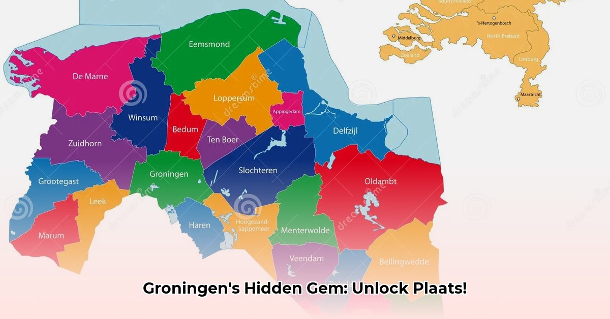
Our analysis focuses on two Wikipedia pages dedicated to listing Groningen's settlements: the Dutch and the English versions. The Dutch version offers a significantly more detailed and comprehensive list, including smaller settlements and employing a more nuanced terminology (such as dorp, gehucht, buurtschap, and wierde). The English version, while useful, presents a more generalized overview, focusing primarily on larger towns and villages. Both sources, however, suffer from limitations, often lacking crucial information such as precise geographical coordinates, population figures, and historical context. This lack of consistency presents a challenge for anyone seeking a complete and accurate picture of Groningen's settlements.
A Head-to-Head Comparison: Consensus and Discrepancies
Both Wikipedia pages concur on the major urban centres of Groningen, Delfzijl and Appingedam, as well as several other prominent towns and villages. However, significant differences emerge when examining smaller settlements. These discrepancies manifest in several ways:
Discrepancies in Classification: A settlement classified as a dorp (village) in the Dutch version might be listed as a gehucht (hamlet) or even omitted entirely from the English version. This stems from differing criteria for defining these settlement types alongside inconsistencies in data entry. For example, 't Zandt is classified differently across the two sources.
Missing Settlements: Some settlements are listed in one source but not the other. For instance, a smaller hamlet, or even a cluster of farms, might be mentioned in the detailed Dutch Wikipedia but be absent from the English version. This highlights the inherent limitations of relying on a single data source. The lack of comprehensive data on smaller settlements is particularly troublesome for accurate mapping and resource allocation.
Inconsistent Municipality Assignments: The municipality to which a given settlement belongs can also vary between sources, reflecting historical changes in municipal boundaries or simple data entry errors. Such issues highlight the challenges associated with maintaining consistency in geographical data over time.
The Root of the Problem: Explaining the Inconsistencies
Several factors contribute to the observed discrepancies:
Evolving Municipal Boundaries: Historical changes in municipal boundaries often lead to inconsistencies in the assignment of settlements. A settlement that once belonged to one municipality might now fall under another, leading to discrepancies in different databases.
Varying Classification Criteria: Different sources may employ varying criteria for classifying settlements, leading to different categorizations (e.g., dorp, gehucht, buurtschap). The lack of standardized terminology compounds the issue. A wierde, for instance, refers to an ancient, elevated settlement, a term possibly unfamiliar to editors of the English Wikipedia page.
Data Entry Errors: Simple human error in data entry also contributes to discrepancies. Such errors might involve incorrect spellings, missed entries, or misclassifications.
Actionable Intelligence: Improving Groningen's Settlement Data
Bridging these data gaps requires a concerted effort:
Provincial Government Initiative: The provincial government should lead the creation of a centralised, comprehensive database. This database should incorporate information from multiple sources, employing consistent terminology and incorporating geographical coordinates, population data, and historical context. This would ensure that services are properly delivered.
Researcher Collaboration: Researchers can play a vital role. By conducting field research, verifying existing information and collaborating with government agencies, a far more comprehensive and accurate inventory of Groningen's settlements can be established.
Tourism Industry Engagement: A complete and up-to-date record of settlements benefits the tourism sector. This would allow for the development of more comprehensive and accurate maps, improved tourism guides and support the creation of richer digital resources.
Data Harmonization Efforts: Advanced data techniques can be leveraged to identify, reconcile, and correct inconsistencies across the datasets, reducing ambiguity and errors in future data collection.
Conclusion: The Path to a More Complete Picture
The discrepancies uncovered in this analysis underscore the need for a more robust and unified database of Groningen's settlements. By embracing collaboration between the provincial government, researchers, the tourism industry, and data experts, we can achieve a more complete and accurate understanding of this fascinating province's rich geographical landscape. This will benefit everyone, from researchers requiring reliable data to tourists seeking to explore Groningen's hidden gems.